Dr. Amanda Regan, my supervisor and co-director of the digital mapping project Mapping the Gay Guides, first introduced me to AirTable when I started to work as a research assistant in the project. Since Mapping the Gay Guides depends on the collaborative work between many researchers and graduate students from California State University at Fullerton to Clemson University, AirTable serves us well as a cloud-based database platform. AirTable is a relational database that allows for a unified workflow and data management system between different parties in a collaborative project like MGG.

Working with the MGG Project provided me with a practical overview of what the platform can offer. In historical research, transforming information into data is an important step to develop digital scholarship that relies on computational processes and algorithmic thinking. One of my first tasks as a research assistant was to transcribe data from Bob Damron’s original guides from 1981 to 1985. I transcribed over 200 records for the U.S. Territories (Virigin Islands, Puerto Rico, and Guam) into a base in AirTable following its data schema.
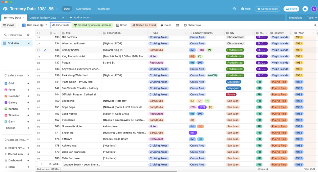
The data structure in AirTable works in a way that fields are interrelated through linked records, making it a very useful relational database. In the example above, each record is an unclear address of Bob Damron’s Gay Guides in the U.S. Territories, and fields reflect the information from the Guides transcribed in form of data. Since the MGG Project involves so many collaborators from different areas, we use the controlled vocabulary feature of AirTable to ensure data integrity when transcribing and entering records into the bases. This is likely one of the most powerful features of the platform. Differently from common Excel spreadsheets, AirTable’s controlled vocabulary makes it easy to track misspelling errors. For example, one cannot enter “cruisy areas” as an amenity feature for a location without having it spelled exactly like “Cruisy Area” as the predefined option for the field. Otherwise, AirTable will notify the user that a new option of category was created, and if not intentional, it should be removed from the list.

As a historian, I am always looking for ways to improve consistency throughout my methodological choices. When I was working for the Geospatial Centroid at Colorado State University, I faced the challenge of mapping more than 200 locations for a project with the Larimer County Department of Natural Resources. In that occasion, when I still had not heard of AirTable, I used an Excel spreadsheet to transform the information of each of those locations into consistent data before geolocating them and making a Web Map with particular attributes for each feature. The result, as you can imagine, was messy. Without a controlled vocabulary feature, the spreadsheet contained multiple inconsistencies throughout the entries.
Another obstacle was not being able to assign one particular record multiple categories in the same field. For that particular project, I was assigning each of those entries particular categories according to the procedures and criteria of the Department of Natural Resources. Some entries, however, fell into multiple categories. In an Excel spreadsheet, there is not an easy way to enter multiple values in the same field besides manually differentiating them with an ordinary separator like semicolon.

AirTable is not a solution for every problem in data consistency and integrity assurance, but it provides digital historians with more functionality to work on their data. Transforming historical information into data is the first step for many digital historians who seek to visualize and analyze information in less traditional ways, and it requires consistent methodological rigor. Zotero, Tropy, and AirTable could be the preliminary toolbox of historians who are hoping to become more familiar with digital humanities approaches and the idea of looking at data (or capta) instead of simply textual information. These tools meant the start of a whole new way of working and scholarly practice for me. And I’m excited to see how my own practice changes in the course of the next five years while I pursue a Digital History Ph.D. degree.